
Best Scenic Routes in Southern California
- Nov 12, 2025
- 4 min read
Updated: Nov 13, 2025
Southern California offers some of the most breathtaking drives in the United States. From rugged coastlines to winding mountain roads, the region’s diverse landscapes create unforgettable experiences for travelers. Whether you want ocean views, desert vistas, or forested highways, the best scenic routes in Southern California deliver stunning sights and memorable stops along the way.

Pacific Coast Highway (Highway 1)

The Pacific Coast Highway, often called PCH, is the most iconic scenic route in Southern California. Stretching from Dana Point in Orange County up to Malibu and beyond, this highway hugs the coastline and offers spectacular views of the Pacific Ocean.
Travelers can stop at beaches like Laguna Beach or Crystal Cove State Park to enjoy the sand and surf. The route also passes through charming towns such as Newport Beach and Huntington Beach, where you can explore local shops and restaurants. For a quieter experience, the stretch near Malibu features rugged cliffs and hidden coves.
Driving the PCH is about more than just the views. It’s a chance to experience the coastal lifestyle, with opportunities for hiking, surfing, and dining with oceanfront views.
Angeles Crest Highway (State Route 2)

For travelers who prefer mountain scenery, the Angeles Crest Highway offers a dramatic change of pace. This route climbs through the San Gabriel Mountains, providing a mix of pine forests, rocky outcrops, and panoramic views of the Los Angeles basin.
Starting near La Cañada Flintridge, the highway winds through Angeles National Forest and reaches elevations over 7,000 feet. Along the way, you can stop at spots like the Switzer Falls trailhead or the Red Box Picnic Area for short hikes and nature breaks.
The road is narrow and winding, so it’s best suited for drivers who enjoy a more adventurous ride. In winter, parts of the highway may close due to snow, but during warmer months, it offers a refreshing escape from the city heat.

Route 66 through San Bernardino and Victorville
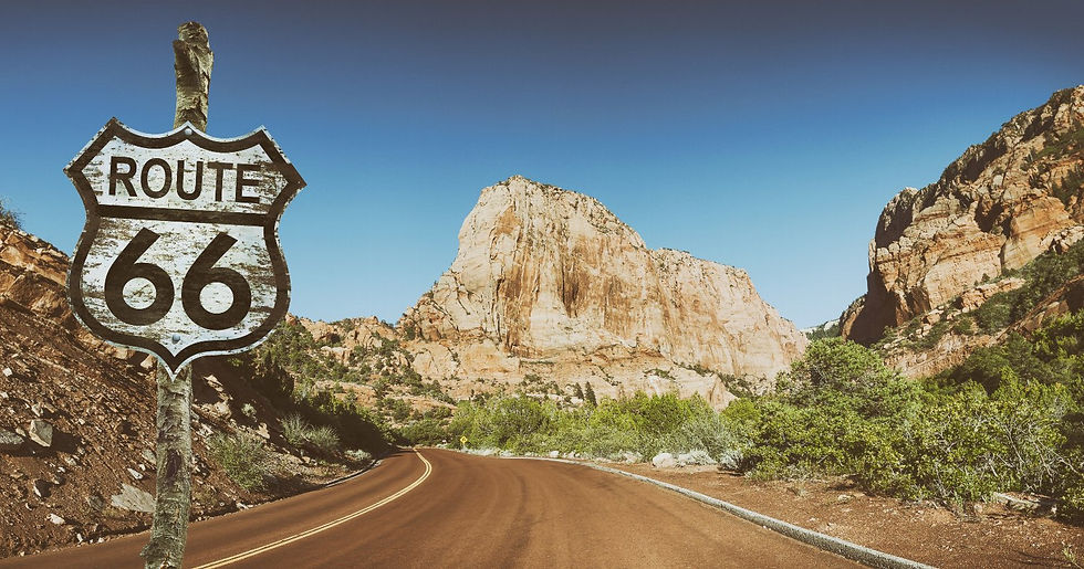
Historic Route 66 runs through parts of Southern California, offering a nostalgic drive with vintage roadside attractions and classic diners. The stretch between San Bernardino and Victorville is particularly popular for travelers interested in Americana and history.
Along this route, you’ll find old motels, neon signs, and museums that celebrate the heyday of the Mother Road. The Mojave Desert landscape adds a unique backdrop, with wide-open skies and rugged hills.
This drive is ideal for those who want to combine scenic views with a cultural experience. Stop at the Route 66 Museum in Victorville or grab a burger at a classic diner to soak in the atmosphere.

Ortega Highway (State Route 74)

Ortega Highway connects the inland city of Lake Elsinore with the coastal town of San Juan Capistrano. This route is a favorite for drivers who enjoy twisty roads and a mix of mountain and valley views.
The highway passes through the Cleveland National Forest, offering glimpses of chaparral-covered hills and occasional wildlife sightings. The road’s curves make it popular with motorcyclists and sports car enthusiasts.
Along the way, you can stop at the Ortega Oaks Candy Store or explore hiking trails near the Ortega Oaks Fire Station. The route also provides access to the historic Mission San Juan Capistrano, a beautiful landmark worth visiting.

Palms to Pines Scenic Byway

This lesser-known route takes travelers from the desert floor near Palm Springs up into the cooler mountain town of Idyllwild. The drive climbs over 5,000 feet in elevation, moving from arid desert landscapes to pine forests.
The contrast between the two environments is striking. Starting in the Coachella Valley, you’ll see palm trees and sand dunes. As you ascend, the scenery changes to oak woodlands and eventually dense pine forests.
Idyllwild is a charming mountain town with art galleries, cafes, and hiking trails. It’s a perfect destination for those who want to combine a scenic drive with outdoor activities and small-town charm.

Tips for Enjoying the Best Scenic Routes in Southern California
Plan your stops: Many scenic routes have viewpoints, parks, and small towns worth exploring. Research ahead to make the most of your trip.
Check road conditions: Mountain roads like Angeles Crest Highway can close due to weather. Verify conditions before you go.
Drive during daylight: These routes are best enjoyed with clear visibility. Avoid night driving on winding roads.
Bring a camera: The views are often spectacular and worth capturing.
Pack snacks and water: Some stretches have limited services, so be prepared.
Southern California’s scenic routes offer a variety of landscapes and experiences for travelers. Whether you prefer ocean views, mountain roads, or desert escapes, these drives showcase the region’s natural beauty and unique character. Planning your trip around these routes guarantees memorable moments and stunning sights.
If you're looking for a rental van for your group, we serve a wide range of locations, including San Diego, San Bernardino, Riverside, Los Angeles, Orange County, San Francisco, Las Vegas, Phoenix, and many more. We also provide complimentary delivery/pick-up to LAX, SAN, and PHX Airports!

If you'd like more personalized assistance in planning trips in and around San Diego, get in contact with our local travel concierge, Patty of Mindful Miles Travel


Comments